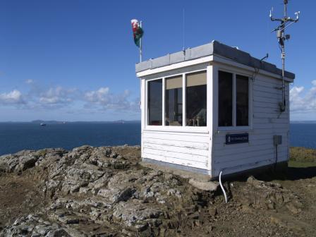
Wooltack Point

Welcome to NCI Wooltack Point Station    

Croeso i Orsaf NCI Wooltack Point

Opened in 2009, Wooltack Point is a small station situated between St Brides Bay and Milford Haven. Surrounded by stunning coastal scenery, our watchkeepers keep a daily watch and listen out for the safety of fishing vessels, oil tankers and ferries, not to mention the many numbers of leisure vessels, kayakers, divers and walkers that enjoy this special area. 

Are you interested in becoming a watchkeeper? Please contact us - call 07927 321164 or email us at wooltack.point@nci.org.uk

Come and visit us! 

Cafodd ei hagor yn 2009, mae Wooltack Point yn orsaf fach yn sefydlwyd rhwng Bae Sain Fraid ac Aberdaugleddau. Wedi'i amgylchynu gan olygfa hardd, mae ein gwirfoddolwyr ni'n cadw golwg a gwrando am y diogelwch o fadau pysgota,llongau olew a fferiau, heb son am y badau hamdden, a phobol yn deifio, caiacio a cherdded yn yr ardal arbennig hon.

Oes gennych chi ddiddordeb mewn dod yn fonitor? Cysylltwch â ni - ffoniwch 07927 321164 neu anfonwch e-bost atom yn wooltack.point@nci.org.uk

Dewch i ymweld â ni! 

Visitor Policy
We are more than happy to receive visitors into our station and show them what we do. Wooltack Point is a very small station, so it may only be possible to have a couple of guests at a time. During busy times, the watchkeepers on duty may not be able to invite members of the public in, but will be happy to invite them back at a more convenient time.
Access

Access to the lookout station is from a walled entrance to The Deer Park, close to the NT car park at Martin's Haven. Enter The Deer Park through a gate and then ascend the steps directly opposite. Take care as these steps are a little steep and can be slippery after rain. Once at the top of the steps, follow a path to the right for about 200m to the station.

Local Hazards
The station overlooks the dangerous channel of Jack Sound, which has the additional hazards of rocks such as: The Crabstones, The Anvil, Tusker Rock and The Blackstones. Strong tidal streams operate around The Deer Park and the surrounding islands; up to 6 knots through Jack Sound. These can cause races and overfalls; notably in Jack Sound and the dangerous Wild Goose Chase to the west of Skokholm. Musselwick Sands is a beach within telescope range of the station, where it has been known for members of the public to be cut off by a flooding tide. All of The Deer Park has very steep cliffs and vertical drops in places, which become more hazardous due to their exposure to high wind speeds.
Operational capability
This station awaits assessment for Declared Facility Status
This station reports to MRCC Milford Haven
Current weather and sea conditions are available via Ch65 or by telephone during watch hours
Defibrillator Available: 
Mounted externally available 24 x7 call number displayed on unit for instructions
Station Telephone: 
01646 795195
Visual Watch: 
Yes
Radar Watch: 
No
NAVTEX: 
No
AIS Watch: 
Yes
CCTV Watch: 
No
DSC Watch: 
No
Radio: Listening watch on channels: 
12
16
67
73
Radio: Channels in use (call direct not via ch 16): 
65
Radio: Channel 00: 
Listening watch and ready to transmit as authorised by Coastguard
Station Call Sign: 
Wooltack Point NCI
Other Watch Information: 
Gelliswick Bay NCI
Visual Horizon: 
15.7 nautical miles

Station Info

Station Address
No Postal address!
Martin's Haven
Milford Haven
Pembrokeshire
SA62 3BJ
c/o SM, 20 South Hook Rd, Gelliswick, Milford Haven, SA73 3RU
Station telephone number
01646 795195
Station email address
Station contact
Haydn Evans
Station contact role
Station Manager
07927 321164
Station website

1No Lenovo Tablet HADX7ZP4
1N Sony 14" VGA Monitor
1No Dell 16" DVI/VGA Monitor


Summer opening
Open from: 
10:00
Open until: 
18:00
Days: 
Monday
Friday
Saturday
Sunday
From: 
Sunday, March 31, 2024
Until: 
Sunday, October 27, 2024
Notes: 
Summer watches are kept from the start of BST. Watchkeepers may remain on watch in the event of an emergency or circumstances which may require monitoring.
Winter opening
Open from: 
10:00
Open until: 
16:00
Days: 
Monday
Friday
Saturday
Sunday
From: 
Sunday, October 27, 2024
Until: 
Sunday, March 30, 2025
Location
Latitude: 
51°44.20'N
Longitude: 
005°14.85'W
OS Reference: 
SM 759 092
Station Elevation: 
187'/57 metres
what3words: 
///swordfish.ramps.units
Visual features of station
The lookout is a timber single story building with a 2.5 metre flagstaff.